Native American Veterans Highway
In 2019, a joint resolution of the Arizona State Senate designated a section of U.S. Route 89 from Flagstaff to the Arizona-Utah border as the Native American Veterans Highway. A designation honoring 29 Navajo Marine Corps radio operators who encrypted their native language to provide strategic military communications during World War II. Referred to as ‘Navajo Code Talkers’, the original 29 and nearly 400 others are credited with helping the United States win World War II. Today, this commemorative highway traces the western edge of the Navajo Nation’s semi-autonomous territory in Arizona. For a motorcycle rider, the path of travel can be a spiritual journey through a desert solitaire. Scenic canyon overlooks, century-old Pueblo dwellings, and remnants of the youngest volcano eruption on the Colorado Plateau are just a few of the remarkable waypoints worth stopping at along this route.

Navajo code talkers photographed in 2005 at Monument Valley, Utah. Photograph by Kenji Kawano.
Native American Veterans Highway begins in Flagstaff and passes by the western base of Humphrey’s Peak, Arizona’s highest point at 12,600 feet. The first waypoint on this route is Cinder Hills OHV, a popular off-road recreation area situated in the heart of the San Francisco Volcanic Field and Coconino National Forest. To get to Cinder Hills, take Forest Service Road 776 until you reach the clearly marked entry signage. The soil throughout the 13,500 acre area is made of volcanic ash and cinder deposits, making the terrain challenging to ride. Sand riding skills will help you navigate through the terrain successfully. Tips: stand up on the pegs, shift your weight to the rear, keep a light grip on the handlebars and try to stay pointed in the direction you want to go. Dispersed camping is permitted on a first-come, first-served basis. There are no services available so be sure to bring plenty of water. While you're there, please leave no trace, and remember to pack out whatever you pack in.

Northern Arizona’s San Francisco Peak Mountain Range - 35.342757° N, 111.436180° W

Cinder Hills OHV - 35.342792° N, 111.436308° W

Sunset Crater Volcano - 35.3642° N, 111.5040° W
Photo obtained from Arizona Office of Tourism
After leaving Cinder Hills OHV continue north on Native American Veterans Highway until you reach Fire Road 545 to Sunset Crater Volcano and Wupatki National Monument. Follow the 35-mile Sunset Crater-Wupatki Loop, as it winds through a lava lake trail and picturesque volcanic field with distinct changes in elevation and landforms. Sunset Crater is the most recently active volcano on the Colorado Plateau and was born in a dramatic series of eruptions nearly one-thousand years ago. When leaving Sunset Crater National Monument, the 2,000 foot decent leads to wide-open juniper grasslands with scenic views of red rock formations and the painted desert in the distance.
Upon entering Wupatki National Monument, you will find the protected area offers a rare opportunity to travel back in time to an era where culture and trade thrived in the environment. If you want to really immerse yourself in the history of this region, then venture off the beaten path on Wukoki Pueblo Trail to an impressive eight-room structure built on top of a large sandstone pedestal. This scenic loop (including Wukoki Pueblo Trail) stretches 51 miles and reconnects with Native American Veterans Highway approximately 14 miles north of the Sunset Crater entrance. This quiet detour offers unique access to historical landmarks that many Arizonans aren’t even aware of. The Bonita Campground in the Sunset Crater National Monument offers a great option to set up camp at one of their tent sites for the night to enjoy stargazing under the Northern Arizona dark sky.

Wupatki National Monument - 35.55750° N, 111.39583° W

Wukoki Pueblo - 35.53017° N, 111.32899° W

Wupatki Pueblo - 35.524374° N, 111.373379° W
Leaving the national monument area, continue on the main route heading north on Native American Veterans Highway. The road immediately becomes a secluded 100-mile passage through the Navajo Nation Reservation, eventually reaching the Utah border. Be prepared for limited high octane fuel pumps, narrow highway lanes and shoulders, and scarce rest stops. This section of the journey is pure solace as you ride through the remote high desert surrounded by iconic views of colorful staircase rock layered formations. There are many wild Navajo Horses in the area, and if your timing is right, you’ll get a chance to see them near the roadside. It's a truly peaceful experience that lets you feel connected to nature and in harmony with your surroundings.

Wild Navajo Horse near junction of Native American Veterans Highway and 89A at Vermillion Cliffs - Photograph by JMY Photography

Antelope Pass Vista - 36.6609° N, 111.6331° W
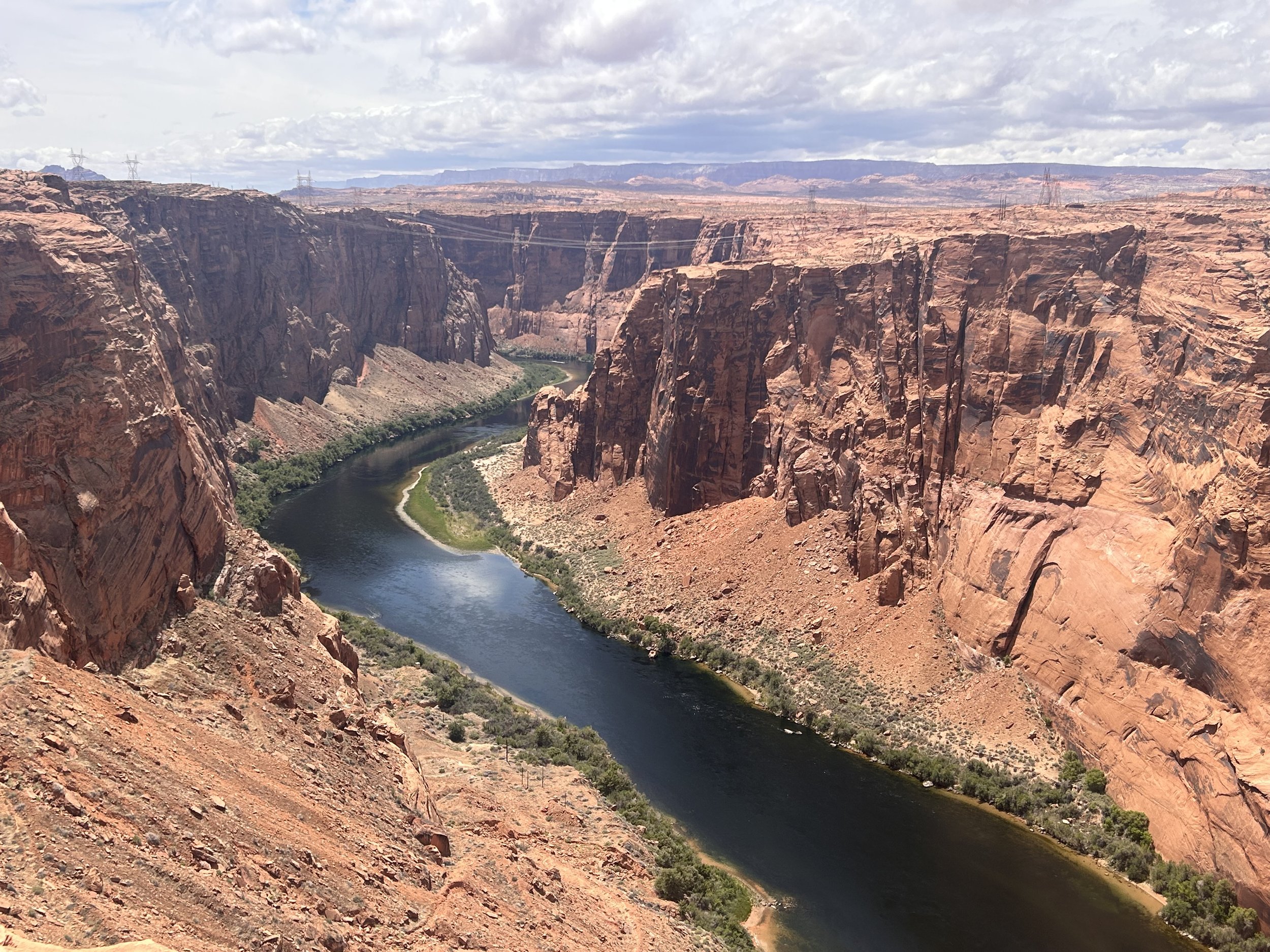
Glen Canyon - 36.9244° N, 111.4784° W
The final 34 miles of this route is packed full of iconic views of the American Southwest. The initial ascent of 1,000 feet in 3 miles traverses the Echo Cliffs and reaches Antelope Pass on the Kaibito Plateau. A brief stop at the roadside Antelope Pass Vista is totally worth the time to capture some amazing views of Marble Canyon. It’s best experienced at dusk or dawn. The final stretch of this route leads to the city of Page where you can view the Colorado River as it flows through Glen Canyon creating Lake Powell on its way to the Grand Canyon. Heads up, this section of the route can get touristy during peak season. The Native American Veterans Highway ends at the Utah border. Once you've crossed over the Glen Canyon Dam, you will be on a remote, quiet road that runs west to the border.
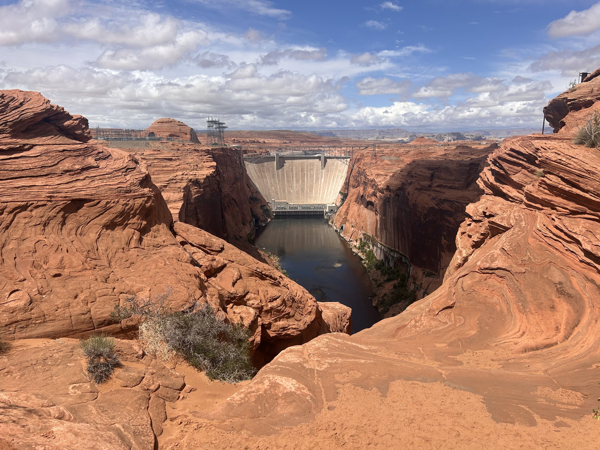
Glen Canyon Dam - 36.9372° N, 111.4837° W

Utah Border - 37.00253° N, 111.57383° W
The Native American Veterans Highway extends 159 miles including the waypoints described in this logbook entry. It is a route worth every mile and introduces you to unique landscapes of Northern Arizona and the American Southwest. The highway’s name pays respect to the heritage of a Native American people and to the significant service of the Navajo Code Talkers. Riding this route is a great way to honor the service of these American heroes. While the roadway has been around for some time, this renaming is a positive development, and I can't help but feel that it has made an exceptional motorcycle riding experience that much better.
Enjoy the adventure and ride safe.
Note: Mileages are approximate. Each rider is responsible for checking the current road conditions and assessing their own skills to ensure safety. All routes are provided "as is" without any liability.
Discalimer: Logbook entry content here is original and not AI-written. It consists of my personal accounts after scouting the routes myself. Each route description is submitted for AI detection and plagiarism before being published.
Copyright Protected © 2025 Lost Highways LLC. All rights reserved.